The Integration of Web GIS and AI in Geographic Information Systems
The rapid advancement of technology has led to the integration of Web GIS and Artificial Intelligence (AI) in Geographic Information Systems (GIS). These innovations are revolutionizing the way spatial data is collected, analyzed, and visualized, leading to more informed decision-making and enhanced problem-solving capabilities. In this blog, we delve into the transformative impact of Web GIS and AI GIS on the field.
Understanding Web GIS and AI GIS
Web GIS
Web GIS refers to the use of web technologies to deliver GIS capabilities over the internet. It enables users to access, share, and analyze spatial data through web-based interfaces, making GIS more accessible and collaborative.
AI GIS
AI GIS involves the integration of artificial intelligence techniques with GIS to automate data analysis, pattern recognition, and predictive modeling. AI algorithms can process vast amounts of spatial data quickly and accurately, uncovering insights that would be difficult to detect manually.
Benefits of Web GIS
Accessibility and Collaboration
Web GIS allows users to access GIS data and tools from anywhere with an internet connection. This democratization of GIS makes it accessible to a broader audience, facilitating collaboration among stakeholders.
Example:
Local governments can use Web GIS to share spatial data with citizens, enabling public participation in urban planning and development projects.
Real-Time Data
Web GIS supports real-time data collection and analysis, providing up-to-date information for decision-making. This is particularly valuable in emergency response and environmental monitoring.
Example:
During natural disasters, Web GIS can provide real-time maps of affected areas, helping responders to allocate resources efficiently.
Benefits of AI GIS
Enhanced Data Analysis
AI algorithms can analyze large datasets to identify patterns and trends that may not be apparent through traditional analysis methods. This leads to more accurate and reliable results.
Example:
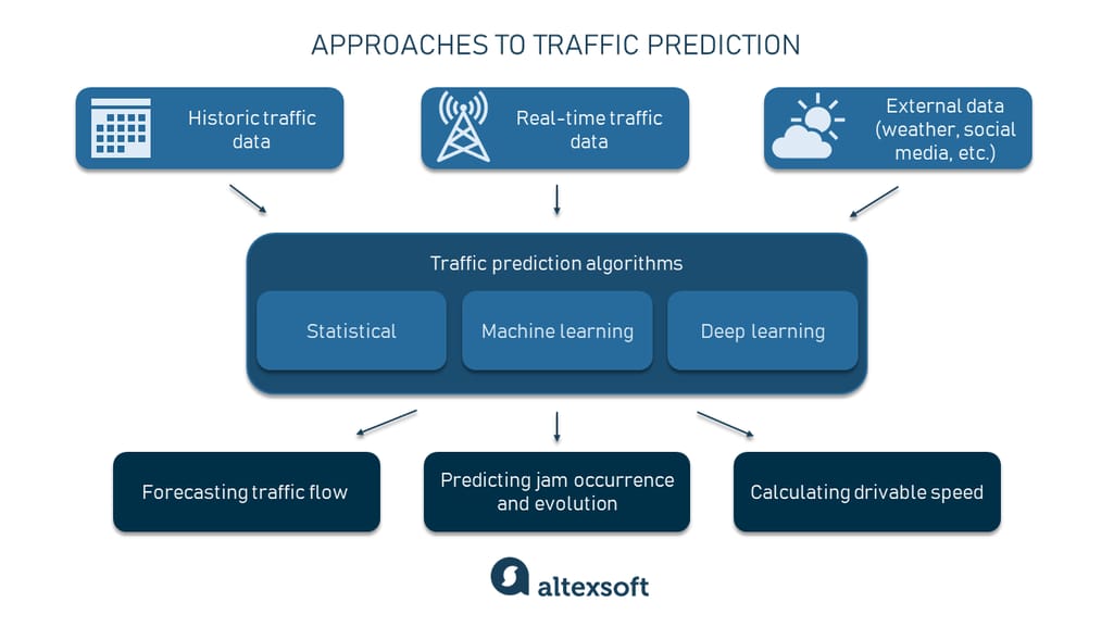
AI GIS can be used to predict traffic patterns and optimize transportation planning, reducing congestion and improving mobility.
Automation and Efficiency
AI can automate repetitive GIS tasks, such as data classification and feature extraction, increasing efficiency and reducing the potential for human error.
Example:
In agriculture, AI GIS can automatically classify crop types from satellite images, helping farmers to monitor crop health and optimize yields.
Applications of Web GIS and AI GIS
Smart Cities
The integration of Web GIS and AI is crucial for the development of smart cities. These technologies enable the collection and analysis of data from various urban systems, enhancing the efficiency and sustainability of city operations.
Example:
Smart city platforms can use AI GIS to monitor air quality, manage waste collection, and optimize energy consumption.
Environmental Monitoring
Web GIS and AI GIS are powerful tools for environmental monitoring and conservation. They provide the capabilities to track changes in the environment, model future scenarios, and develop strategies for sustainable management.
Example:
AI algorithms can analyze satellite imagery to detect deforestation and predict areas at risk, helping to guide conservation efforts.
Challenges and Considerations
Data Privacy and Security
The widespread use of Web GIS and AI GIS raises concerns about data privacy and security. Ensuring that sensitive spatial data is protected from unauthorized access is crucial.
Technical Expertise
Implementing and utilizing Web GIS and AI GIS requires specialized technical skills. There is a need for ongoing education and training to develop a workforce capable of leveraging these technologies effectively.
Future Outlook
The future of GIS lies in the continued integration of Web GIS and AI. These technologies will become increasingly sophisticated, providing deeper insights and more powerful tools for spatial analysis. As AI continues to evolve, we can expect to see even greater automation and predictive capabilities in GIS applications.
Innovations on the Horizon
-
AI-Driven Decision Support: Advanced AI algorithms will provide decision-makers with actionable insights, enhancing the effectiveness of GIS in various fields.
-
Integration with IoT: The Internet of Things (IoT) will provide real-time data streams to Web GIS platforms, enabling more dynamic and responsive spatial analysis.
-
3D and Augmented Reality (AR): The use of 3D mapping and AR will enhance the visualization of spatial data, providing more immersive and interactive GIS experiences.
Conclusion
The integration of Web GIS and AI GIS is transforming the field of Geographic Information Systems, making spatial data more accessible, analyzable, and actionable. These technologies are driving innovation across various sectors, from urban planning and environmental monitoring to transportation and agriculture. As we continue to explore the potential of Web GIS and AI, the possibilities for enhancing our understanding and management of the world around us are boundless.
References
- Esri, "What is Web GIS?" 2023. Read more
- Geospatial World, "AI and GIS: The Perfect Match," 2023. Read more
- National Aeronautics and Space Administration (NASA), "AI and Remote Sensing," 2023. Read more
- United Nations Environment Programme (UNEP), "Using GIS for Environmental Conservation," 2023. Read more
Visual Aids
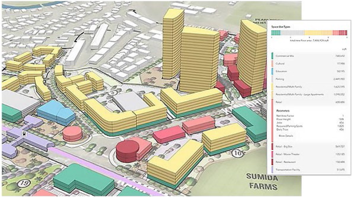
Urban Planning

Traffic Prediction